
Did you know that registration to Fighter Control is completely free and brings you lots of added features? Find out more....
Monday/Tuesday Thunderstorm Heads Up
-
RichC
Re: Monday/Tuesday Thunderstorm Heads Up
Yeah, they are good. You don't necessarily need a 30sec exposure. But all depends on how lively the storm is. If its chucking CG's down left right and centre then use 30 secs to get multiple CG shots... for example, really active storm you could get 2-5 CG's in one exposure and it looks cool. If you wanted to catch individual CG's then speed up the shutter to say 10 secs. But then if the storm isn't that active, 30secs will/might catch just 1 CG
-
TankBuster

- Posts: 1710
- Joined: Mon Oct 05, 2009 8:45 am
- Location: Colchester
Re: Monday/Tuesday Thunderstorm Heads Up
Excellent images  .
.
Just wondering... Anybody know if there is any way of telling how far away that lightning bolt is from the camera in Stuart's image?
TankBuster
Just wondering... Anybody know if there is any way of telling how far away that lightning bolt is from the camera in Stuart's image?
TankBuster
And there's plenty more where that came from!

Re: Monday/Tuesday Thunderstorm Heads Up
Not being local to the area, its was difficult to say just how far away, but my feeling was that the lighting in those shots was over the Ely/Littleport area, but maybe further Northwest?TankBuster wrote: Just wondering... Anybody know if there is any way of telling how far away that lightning bolt is from the camera in Stuart's image?
But the Storm was all around me, from the South to the West and the North.
I believe many parts of the country had some good storms on Monday/Tuesday.
-
RichC
Re: Monday/Tuesday Thunderstorm Heads Up
There is no way of telling just from an image. Although most lightning bolts are only approx 1 inch in diameter, even lightning 10 miles away can look very close. The only way of knowing is from the person knowing when taking the photo when it happened. Every 5 seconds for 1 mile. But that's difficult if you have multiple lightning coming down.
Just one cell can produce lightning several miles apart at any one time, sometimes up to 10 miles from the storm (called bolt from the blue).
The only other way is to get an approximate from the radar echo. Although this will jut show the cell size.
ATD lightning detectors are extremely accurate (Like that on Met Office and BLIDS) but that still won't help as they can still be a few miles out.
By the way, don't rely on the Bolteks or Stormvue detector sites, they are notoriously inaccurate especially during large MCS type storm systems and get very "confused".

Re: Monday/Tuesday Thunderstorm Heads Up
Heavy thunderstorms in the Highlands at present, Rich - what's the photo in your avatar of, it's been driving me nuts for months ? !
Re: Monday/Tuesday Thunderstorm Heads Up
Mike
Looks like the longwire from the rear of an E-6....
Looks like the longwire from the rear of an E-6....
-
RichC
Re: Monday/Tuesday Thunderstorm Heads Up
Mike,
It's the rear end of the E-6B Mercury. Another big part of my aviation hobby is Stratcom. Mr Stihl is correct, it is the drogue unit of the short wire (5000ft long).
As for storms today, most of the country was peppered with home growns today and destabilised by the trough moving SW - NE. Sadly for me, about 10 cells developed over me only to fire up just 10-20 miles east of me so i got torrential rain but no thunder.
-
TankBuster
- Posts: 1710
- Joined: Mon Oct 05, 2009 8:45 am
- Location: Colchester
Re: Monday/Tuesday Thunderstorm Heads Up
I captured this beauty this morning!
This was taken on the edge of a huge storm just east of Colchester at 09.20, so the town itself must have been directly under this lot & probably took quite a wallop as there was plenty of flashing & banging going on!
The telephone wires across the front of this first image were hit by lightning about an hour after this storm had passed. The lightning which did the damage was generated by a later storm which can be seen brewing up in the last image at the bottom of the page (glad I was'nt still standing in the same place for that!)
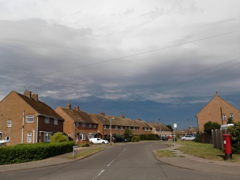
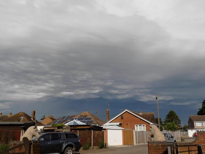
If you look in the distance on this image you can see a huge storm brewing up behind the bushes in the centre of the picture (looks like a grey dome behind the bushes). It was this storm which took down the telephone wires in the first image. The storm in the first and second image was still going on behind me when I took this picture
TankBuster
This was taken on the edge of a huge storm just east of Colchester at 09.20, so the town itself must have been directly under this lot & probably took quite a wallop as there was plenty of flashing & banging going on!
The telephone wires across the front of this first image were hit by lightning about an hour after this storm had passed. The lightning which did the damage was generated by a later storm which can be seen brewing up in the last image at the bottom of the page (glad I was'nt still standing in the same place for that!)


If you look in the distance on this image you can see a huge storm brewing up behind the bushes in the centre of the picture (looks like a grey dome behind the bushes). It was this storm which took down the telephone wires in the first image. The storm in the first and second image was still going on behind me when I took this picture

TankBuster
And there's plenty more where that came from!
Re: Monday/Tuesday Thunderstorm Heads Up
Just been watching from Leamington looking to the west-north west toward Birmingham and there was a lot of potential, viable clouds and reports of lightning activity from Bham approach for inbound traffic, which was heading right into it. It seems to have calmed down a bit now but also updates from a friend who lives near Cosford where there has been a lot of activity.
Cheers
Shane
Cheers
Shane
Still searching for the master shot.
Re: Monday/Tuesday Thunderstorm Heads Up
Re Thursday evening received a text from my daughter to say they had arrived at the Leeds Fest campsite and got the tent up and everything in 2 minutes (!) before the heavens opened.......!!
Re: Monday/Tuesday Thunderstorm Heads Up
Cracking storms over north Norfolk at this time had 15mm of rain in last 45 minutes. Lots of fork lightning hitting the ground and loud claps of thunder passing overhead from west to east.
-
RichC
Re: Monday/Tuesday Thunderstorm Heads Up
A Spanish plume set up is underway and has been all morning as it crossings the ocean towards southern UK. Sferics died down somewhat but have initiated again as discrete cells have developed all over the place on the leading edge. ESTOFEX have issued a level 1 warning for the Southern portion of England from Devon/Somerset border eastwards to Kent and Essex/Suffolk.
Warning is for severe thunderstorms, large hail, tornadoes and damaging straight line winds. Rainfall will be torrential in places. Bare in mind, someone down the road might get everything whereas someone 20 miles away might get just rain.
This watch is in force from 1000 to later tonight. As its angled NW to SE, the SE part of the country will not get activity until later.
Although the severe watch is for the area above, areas west (Devon/Cornwall) will see lots of sferic activity and torrential downpours. Individual cells with sferics are already starting to affect Devon/Cornwall now.
Right now, the sky is very elevated, very unstable and classic plume style sky here in Devon.
-
TankBuster
- Posts: 1710
- Joined: Mon Oct 05, 2009 8:45 am
- Location: Colchester
Re: Monday/Tuesday Thunderstorm Heads Up
Had a cracking storm pass over Colchester tonight!
Started rumbling around 22.30 & developed into some serious c2g with some incredible powerbangs!!!
Both the kids were soon out of bed & down the stairs!
TankBuster
Started rumbling around 22.30 & developed into some serious c2g with some incredible powerbangs!!!
Both the kids were soon out of bed & down the stairs!
TankBuster
And there's plenty more where that came from!
Re: Monday/Tuesday Thunderstorm Heads Up
Had a huge rainstorm blow through Cornwall today, went into Tesco and it was bone dry, came out and it was like a river! Even before you could see the clouds rolling over the fields like a Tsunami. 'Twas Spectacular 
-
bobthehandyman
- Posts: 850
- Joined: Tue Jul 20, 2010 4:29 pm
- Location: Trowbridge, Wiltshire
Re: Monday/Tuesday Thunderstorm Heads Up
Thunder lightning here for the past hour Trowbridge wilts,, Just started to rain! 
-
bobthehandyman
- Posts: 850
- Joined: Tue Jul 20, 2010 4:29 pm
- Location: Trowbridge, Wiltshire
Re: Monday/Tuesday Thunderstorm Heads Up
Thunder lightning here for the past hour Trowbridge wilts,, Just started to rain!
That was a let down, loads of lightning, as the storm got here, massive bolt and thunder within 3/4 seconds, and that was it, nothing more, the end, back to sleep.
That was a let down, loads of lightning, as the storm got here, massive bolt and thunder within 3/4 seconds, and that was it, nothing more, the end, back to sleep.
-
RichC
Re: Monday/Tuesday Thunderstorm Heads Up
You're lucky you got it, the main TS activity was in the morning for our region. However as per the last plume setups, most of the sferic activity stayed out to sea.
The main area for storms last night was for Kent/Essex and they got some great storms.
Your particular storm came out of nowhere over Lyme Bay, as soon as it got orographic lift from the cliffs and blackdowns, it pepped up to atleast 1 strike per minute. Could clearly see it from here in Devon.
The main area for storms last night was for Kent/Essex and they got some great storms.
Your particular storm came out of nowhere over Lyme Bay, as soon as it got orographic lift from the cliffs and blackdowns, it pepped up to atleast 1 strike per minute. Could clearly see it from here in Devon.
-
TankBuster
- Posts: 1710
- Joined: Mon Oct 05, 2009 8:45 am
- Location: Colchester
Re: Monday/Tuesday Thunderstorm Heads Up
Last nights storm just caught the lower part of the Essex coastline, particularly around the River Colne & River Blackwater. The whole Thames Estuary was pretty much dancing with lightning, it was very spectacular to watch  . It also seemed to be quite a slow moving storm, it was still flashing & rumbling in the distance for a good couple of hours as it moved away.
TankBuster
TankBuster
And there's plenty more where that came from!
-
RichC
Re: Monday/Tuesday Thunderstorm Heads Up
Indeed, the initial MCS developed over NW Spain and advected through the Biscay to SW England. The second MCS developed over the Cherbourg Peninsular and headed towards your location. As it developed, it was off the scale, rain/sferic wise over the peninsular.
This time of year, the plumes seem to feed off the air over water and are much more potent when over the sea. Hard to establish how potent and how active they will or won't be once they hit land. Or for that matter even forecasting where exactly it will happen. The models are there but with these set ups, it doesn't always go to plan. But yesterdays activity was well forecast and pretty much did what it said.
The heaviest of rain/prolonged was in the area of the triple point and the associated cold front then harboured the later activity as it moved further east whilst the occlusion and low pressure centre was over the SW England and this produced a small area of thunderstorms around 11.30pm onwards.
Who is online
Users browsing this forum: C24 and 60 guests